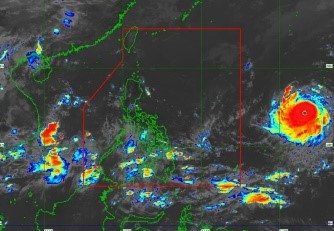
According to Super Typhoon Mawar may head towards Philippines on Friday night | The Star, according to the state meteorological office, Super Typhoon Mawar may make landfall in the Philippine area of responsibility (PAR) on Friday night, May 26.
The Philippine Atmospheric, Geophysical and Astronomical Services Administration (Pagasa) stated at a news conference that Mawar was last observed around 2,000 kilometers east of Southeast Luzon, still outside of PAR.
With maximum sustained winds of 195 km/h and gustiness of up to 240 km/h, it is travelling west northwest at a speed of 15 km/h.
State meteorological expert Daniel James Villamil stated in Filipino that it may begin to approach the Philippine area of responsibility starting tomorrow evening or Saturday early.
By Sunday, Mawar may reach a peak intensity of 215 km/h, he said.
Pagasa is not completely discounting the chance that Mawar will migrate slightly to the south during the following several days. It could be lot more in tune with the nation. According to Villamil, the most severely impacted locations would be in extreme Northern Luzon, including Batanes, the Babuyan Islands, and mainland Cagayan.
According to Pagasa's projection, Mawar may cause Cagayan Valley to experience severe rain between Sunday and Tuesday of next week.
Villamil also brought up a different issue that Pagasa is keeping an eye on: Mawar may intensify the southwest monsoon throughout the weekend until the beginning of next week.
According to Pagasa's projection, Mawar may cause Cagayan Valley to experience severe rain between Sunday and Tuesday of next week.
In addition, Villamil brought up another concern that Pagasa is keeping an eye on: Mawar may intensify the southwest monsoon throughout the weekend and into the first part of next week.
As a result, rain will fall heavily throughout the western part of the nation, including Metro Manila. Villamil reaffirmed that Mawar, which has not yet reached PAR, is not now having a direct impact on the nation.
But, he added, the wind flow is from the southwest.
They will see gloomy skies, sporadic rain, thunderstorms, and lightning in the western region of Southern Luzon, Visayas, and Mindanao, according to Villamil.
Palawan, Western Visayas, Northern Mindanao, Zamboanga Peninsula, Soccsksargen, and Bangsamoro will all continue to experience this weather, he noted.