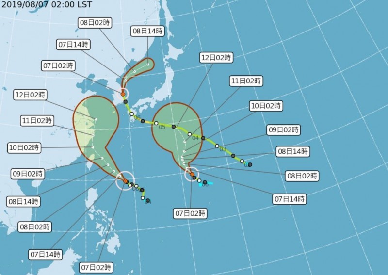
Tropical Storm Lekima, the ninth tropical storm this year, was upgraded to a typhoon last night and is currently on a path to impact northeastern and northern Taiwan, with a sea warning likely to be issued late this morning (Aug. 7), according to the Central Weather Bureau (CWB).
The CWB said that it will likely issue a sea warning for Typhoon Lekima by 11:30 a.m. today, while it may issue a land warning late tonight or early Thursday morning (Aug. 8). The CWB predicts that Lekima will pass through the waters just off the coast of northern Taiwan and could potentially make landfall in northeastern or northern Taiwan.
As of 2 a.m. this morning, Typhoon Lekima was located 820 kilometers east-southeast of Taiwan's southernmost tip of Eluanbi, and moving northwest at a speed of 15 kilometers per hour (kph). The storm has a radius of 220 kilometers and is packing maximum sustained winds of 126 kph with gusts up to 162 kph.
Weather Risk forecaster Lai Chung-wei (賴忠瑋) on his Facebook page this morning said that there are three tropical storms in the Western Pacific, including Lekima, Francisco, and Krosa. Lai said that Typhoon Lekima has increased significantly in strength and size over the past 24 hours and its structure is becoming more and more complete.
The Weather Channel said that Lekima could intensify into the equivalent of a Category 3 hurricane by Friday. The typhoon is likely to come closest to Taiwan on Thursday and Friday (Aug. 9) continuing to increase in intensity along the way, before eventually barreling into China.
Due to the northward movement of Tropical Storm Francisco, the Pacific high-pressure ridge will extend westward to the north of Typhoon Lekima, guiding it to the northeastern coast of Taiwan. Current models indicate that the center of Lekima may pass through the waters north of Taiwan, but the possibility that the typhoon makes direct landfall on the northeastern coast of Taiwan cannot be ruled out.
If the typhoon tracks a little further south, central and southern Taiwan could be shrouded in the storm's circulation belt. The CWB predicts that Taiwan will already begin to feel the effects of Lekima's periphery today.
As the periphery begins to edge toward Taiwan, showers will begin to fall in northern, northeastern, and eastern Taiwan. Large waves and stormy weather will be seen along the eastern coast today.
WeatherRisk Explore Inc. President Peng Chi-ming (彭啟明) said on Facebook today that Typhoon Lekima will strengthen into an intermediate level typhoon. As its structure becomes more and more complete, lightning in the storm's circulation belt will begin to increase, said Peng.


